Where is Saddle Mountain?
The Saddle Mountains are a small group of some very tall, gorgeous mountains about an hour northwest of Phoenix, AZ near Tonopah, AZ.
They are a popular boondocking site because of the large BLM camping area at the base of them.
Related Product: Make steep hikes a little easier on your knees with TrailBuddy Trekking Poles (click to view on Amazon)
We ended up camping there for two weeks and there wasn’t a day we didn’t have somewhere to explore.
The Saddle Mountains are filled with hikes for all levels of hikers.
There’s an easy hike to some petroglyphs, hikes to the smaller peaks, and the steep scramble to the top of Saddle Mountain itself.
Review For Full Time RVers: Cotopaxi 18L Luzon Del Día Backpack
If you drive to where google maps tell you to you can park in that area, or drive a bit further to another large open circle area and park there.
The hike starts right away and there are no signs anywhere with information about the hike.
That’s why I decided to write this very detailed post about where to go and how to hike to the peak of Saddle Mountain.
It was pretty confusing when we hiked it and we had to use a map from on AllTrails to find the way.
See Also: Best Portable Power Station/Solar Generator For Camping
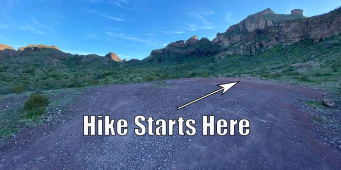
The trail starts out very well walked, but there are a lot of other trails branching off and you need to know which trail to take.
Once you are on the right trail, there are a lot of rocky parts where there’s no way to know where to go except for some rock piles people have made.
See Also: Best Outdoor Bluetooth Speakers Compared & Reviewed
If you ever get lost on the Saddle Mountain trail, look for the rock piles. They are a huge help and will show you the correct way to go.
This post should give you a good enough idea of where you should head so you won’t get lost. There are a few things to know about the hike before you start.
Hiking Saddle Mountain Step-By-Step
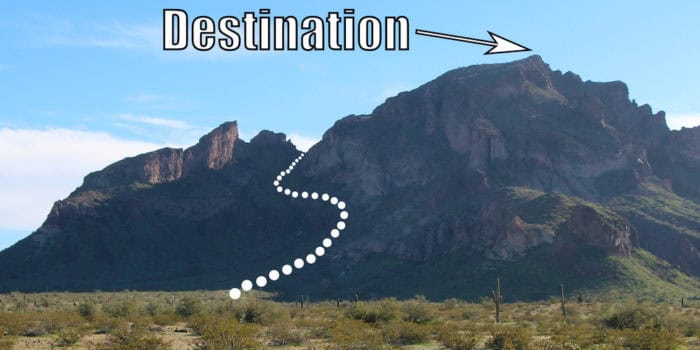
First off, it’s only 2.7 miles from the parking area to the peak, but 2 of those miles are a steep climb up 1,500 feet. In and out, the hike is almost 6 miles total.
Once head up the first hill, it doesn’t really level out until you get near the peak, so be prepared for a strenuous hike.
Even though it’s a short hike, it’s not really for beginners because of how steep it is going up and down. There’s even some climbing involved at one point, so the trail is not dog-friendly.
Bring lots of water and it’s not recommended to hike Saddle Mountain in the summer months because of the intense heat. We hiked it in January and the temperatures were perfect.
If you haven’t hiked in the desert before, wear some sturdy shoes and watch out for cacti and spikes from the Teddy Bear Chollas.
They are very sharp and will go right through the soles of your shoes if you step directly on them. They also hurt really bad when you pull them out.
I recommend bringing some pliers along because you may end up stepping in some and they are almost impossible to pull out by hand.
See Also: How We Store & Transfer Extra Water To Our RV When Camping
There are two large rocks marking where the trail starts and you know you are at the right place if the hike starts out on red rocks, which quickly become a small wash you have to walk across.
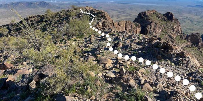
I’m going to use a white dotted line to show the trail and the general hiking area to make the pictures easier to understand.
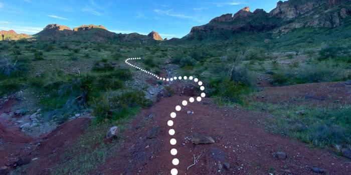
You follow a narrow but well-traveled trail for a few hundred feet before you come to your first fork in the road.
The first time we attempted this hike, I wasn’t following any maps. I assumed the main trail was the right one. Turns out I was wrong.
We went the wrong way and although our little walk around the mountain was beautiful, it did not take us to the top.
If you aren’t following the map on AllTrails make sure you take the trail that shoots to the right and heads straight for Saddle Mountain.
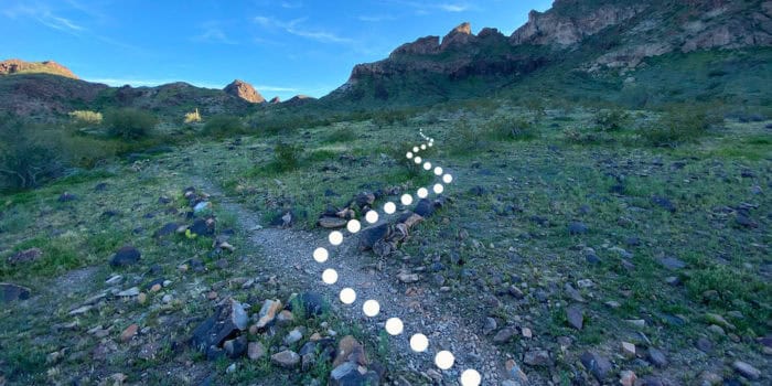
It didn’t feel like we were going in the right direction at all when we started climbing up the side of the mountain but once you get to the top of the first main hill, you see that the other side of Saddle Mountain is steep and untraversable.
See Also: Best Indoor & Outdoor Weather Stations For Home and RV
It looks steeper than it is but after the fork in the road, the hiking trail goes up and the incline doesn’t stop until you basically reach the peak.
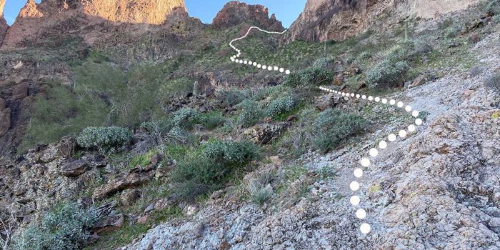
There are a lot of rock faces you have to walk across and it’s very easy to lose the trail if you walk up too high or low.
Luckily, someone has placed rock piles and stacks every so often. If you see them, you know you are going the right way.
Also, it may not seem like it at times, but there is a trail you can clearly see the entire way to the top.
It’s easy to follow small game trails and if the trail gets very narrow and almost nonexistent, you aren’t on it. (We learned this the hard way a few times).
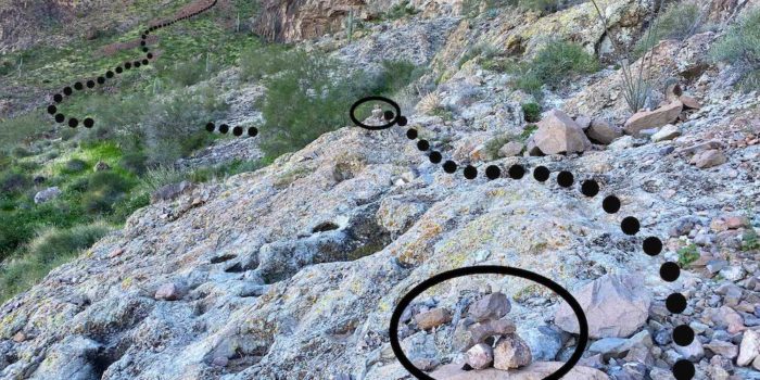
The trail is on loose rocks some of the time, so make sure you have good shoes and follow the rock stacks.
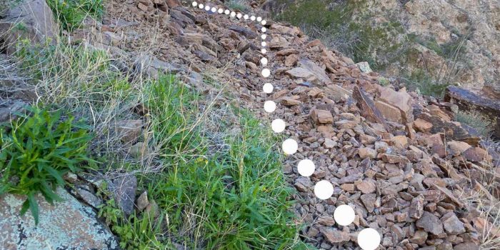
Once you’ve scrambled past the large rock slides, you get to the part where you climb up the back of Saddle Mountain.
There are some great views from this area and it’s a good place to take a break.
See Also: Review Of The Vont Spark LED Headlamp
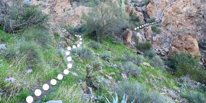
Now things get a little tricky. You’ve reached the top of the first hill and you are now going to climb up the back of Saddle Mountain.
It starts with a steep rock area you basically have to climb up. It’s not so steep you can’t climb up or back down, but it takes some crawling and sliding.
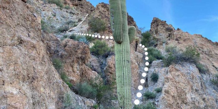
Once you’ve gotten past the climbing part, you come to a large boulder with a small shallow cave.
This is another good spot to take a break and get out of the sun for a while.
It would also be an amazing camping spot for backpackers because it is one of the few level parts of the mountain and the views are amazing from every direction.
See Also: Best Portable Solar Panel Charger For RV Camper/Boondocking
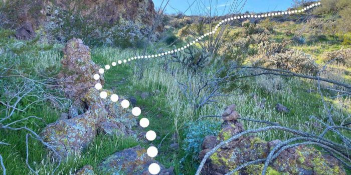
When we did this hike, we had only seen Saddle Mountain from our campsite directly in front of it.
So we weren’t expecting the beautiful valley you get to see once you reach the main ridge.
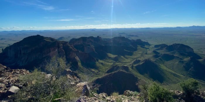
After taking in the stunning view of the rest of the Saddle Mountains, there’s still a bit more hiking to do along the ridge.
This is the part where the Teddy Bear Chollas get really thick, so watch out for their spikes littered all over the trail.
See Also: Best RV Water Filter Systems & Cartridges Reviewed
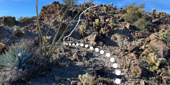
The ridge part of the hike is about a half-mile and you get incredible views from all sides.
You know you’ve reached the peak because there isn’t anywhere else to go. The views are breathtaking and it’s now one of my favorite hikes.
Because Saddle Mountain is basically on its own and not part of a huge mountain range, it feels like you are even more on top of the world than when you hike in the Rockies or Sierras.
You can see for miles and there’s just nothing like seeing the desert in Arizona from Saddle Mountain.
See Also: Best Portable Power Bank/Supply For Travel And Camping
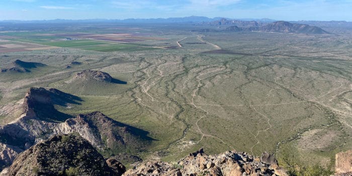
We felt obligated to pull out the drone and get a picture from the top of Saddle Mountain. We’re glad we did.
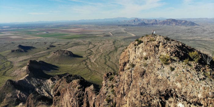
You don’t really feel like there are cliffs all around you, but once you climb back down and look at the peak from the base or from the perspective of a drone, you see that the peak of Saddle Mountain has some crazy drop-offs.
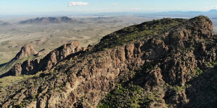
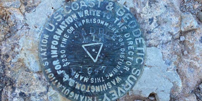
At the top, there is a tin box with some small notepads dating back to 2014. There were pens in it that worked when we were up there, but bring your own just in case.
Or even bring another small notepad in case the one up there is full. It’s always fun to see who has been there and leave your own message for others.
The climb back down from the top of Saddle Mountain is steep with lots of loose rocks and it takes a while to get back. That being said, the hike is amazing and has some amazing views.
See Also: Best Portable Quiet Inverter Generators For RV Camping
I highly recommend it. If you’re lucky, you might even see some Bighorn Sheep or a Desert Tortoise.
Have any questions about the Saddle Mountain Trail? Leave a comment.


Thanks for your write up! I made a go at getting up this mountain yesterday and admittedly didn’t do any research on the correct trail before setting out. I found this post after reading a few others and yours is the best I’ve seen. It not only showed me the way up but where I went wrong. There certainly are many different trails in, on, and around the mountain and I happened up a different one. Was still a fun adventure with astounding views, but not the summit that I was looking for. Excited to give this one a go sometime down the road.
Hey thanks for the comment, we did the exact same thing the first time we tried to do this hike as well. Good luck getting to the top someday. The view from up there is amazing.